
Local to the area? Explore our Illinois service areas.
Land doesn’t fit in a photograph. A quarter section of tillable ground, a timbered 40 with a creek through it, a farmstead with outbuildings scattered across ten acres — the things that determine what a buyer will bid are exactly the things a camera on a tripod can’t see. That’s why land auction marketing across west-central Illinois is going airborne. Over the past two seasons we’ve flown drone video for land sales and farm auctions across Morgan, Greene and Cass Counties — recreational ground, row-crop farmland, multi-tract auctions and rural homes with acreage — and the pattern is consistent: listings with aerial video draw more pre-auction interest, more registered bidders and stronger sale-day energy. This pillar guide walks through six real properties we filmed, one property type at a time, and shows exactly what the drone adds to each.
The Problem With Selling Dirt You Can’t See
An auction is a confidence game in the honest sense: the more certain bidders feel about what they’re buying, the higher they’re willing to go. Traditional land marketing — a plat map, a soil report and a handful of gate photos — leaves the most important questions unanswered. How does the ground lay? Where’s the water? How much timber edge is there really? Is the access lane passable in March? Real estate drone video answers all of it in ninety seconds, before the buyer ever burns a Saturday driving out to walk the property. And the buyers who do come walk it already convinced — which is exactly the bidder you want on auction day.
- Scale reads instantly: 39 acres and 74 acres feel abstract on paper; from 300 feet they’re unmistakable.
- Features become selling points: waterways, timber, terraces, tile-drained bottoms and road frontage all show up on camera.
- Distance stops mattering: out-of-area and investor bidders can evaluate the ground without a site visit — widening the bidder pool.
- The listing travels: a video link forwards through farm families, coffee-shop conversations and Facebook groups in a way a plat map never will.
Recreational & Hunting Ground: The Cox Trust 39
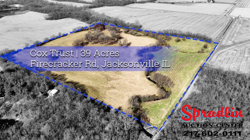
The video at the top of this post is the Cox Trust property — 39 acres near Jacksonville sold as recreational and investment ground. Recreational buyers are emotional buyers: they’re not bidding on tillable percentages, they’re bidding on the picture of themselves on that land in November. The extended uncut flight lets them linger — following the timber lines, tracing the edges where deer move, showing exactly how the parcel sits against neighboring cover. For hunting and recreational tracts, the drone doesn’t just document the property; it sells the daydream that drives the bidding.
Tillable Farmland: 74 Acres on Boyscout Road
Row-crop buyers are the opposite of recreational buyers — they bid with a calculator. For the 74.01-acre Boyscout Road farmland sale, the drone’s job was documentation: clean passes showing how the ground lays, where the field entrances are, how the waterways run and what the crop looked like standing on it. Serious farmland bidders cross-reference what they see from the air against soil maps and yield history, and when the aerial footage confirms the paperwork, confidence — and bidding — goes up. This is commercial drone photography doing quiet, unglamorous work that shows up in the sale price.
Estate Farmland Auctions: Greene County
The J Allen Biggs Jr farmland auction in Greene County is the classic estate scenario: family ground coming to market for the first time in a generation, with heirs who need the sale handled right and neighbors watching how it’s done. Aerial video serves two audiences at once here. For bidders, it presents the ground thoroughly and fairly. For the family, it’s a professional record that the property was marketed at full effort — something auctioneers tell us matters enormously when they’re competing for the next estate listing. In a referral business, the marketing is the resume.
Every land auction has two sales happening at once: the ground on the block, and the auctioneer’s next listing. Drone video wins both.
Multi-Tract Sales: The Orleans Land Auction
Multi-tract auctions are where aerial video stops being nice-to-have and becomes structural. At the Orleans land auction last November, bidders needed to understand not just each tract but how the tracts related — which pieces combine, where the access runs, what the whole assembly looks like as one farm. From the ground that takes a long afternoon and a lot of pointing. From the air it takes one continuous flight. The extended cut let buyers study individual tracts; the shorter promo version pushed the sale date across social feeds in the weeks before the auction. Two edits, one flight, and every serious bidder arrived already oriented.
Rural Homes With Acreage: Murrayville
A country property like 1888 Andras Rd in Murrayville is really two listings wearing one address — a home and land — and each needs its own treatment. The aerial tour orbits the house to show condition and setting, then pulls wide to reveal what the ground-level photos can’t: the full footprint of the acreage, the outbuildings in context, the tree lines and the neighbors (or blessed lack of them). For buyers relocating from out of the area, that wide shot answers the question they care about most — what is it like out there? — better than any description field. It’s the same principle behind the auction real estate work we’ve filmed in Jacksonville: the land around a rural home is half the value, so it should be half the marketing.
The 360 Drone Tour: Meredosia
For 2308 Toe Head Road in Meredosia we produced a different format entirely: a 360-degree drone tour. Instead of a linear video, the camera captures a full sphere from above the property, letting the viewer look wherever they want — pan toward the river bottoms, spin toward the road, study the ground in every direction. For farm auction land for sale where orientation matters (what’s adjacent, what floods, what’s farmable), a 360 gives self-directed buyers a level of control that flat video can’t. It’s also a differentiator: almost nobody marketing land in west-central Illinois is offering interactive aerial tours yet.
What an Auction House Gets From One Flight
- An extended cut for the listing page and serious-bidder due diligence.
- A promo edit sized for Facebook and YouTube, built to push the sale date and drive registrations.
- Aerial stills for sale bills, signage, print ads and the auction catalog.
- A repeatable system: once the first sale runs with video, every consignor after that expects it — and the auction house that offers it wins the listing.
We handle the full pipeline — FAA Part 107-certified flights, editing, formats for every platform — as part of our drone photography and video services. And because auction marketing lives online, the video works hardest when the website underneath it is built to convert; that’s the same thinking behind the real estate website work we’ve done for agents who treat listings as marketing assets rather than paperwork.
Selling Land? Market It From the Air.
Drone video for land auctions, farm sales and rural listings across west-central Illinois — extended cuts, promo edits, aerial stills and 360 tours, flown FAA-certified and delivered ready to post.
FAA-certified • Morgan, Greene, Cass & surrounding counties • From the team at Elevated Ideas
Good To Know
Land Auction Drone Video FAQs
Why does land sell better with drone video?
Because the factors that drive land value — lay of the ground, waterways, timber, access and adjacency — are invisible from the road and obvious from the air. Video lets more buyers evaluate the property earlier, which widens the bidder pool, and confident bidders bid higher. The listing also travels further, since a video link gets shared in ways a plat map never does.
How far ahead of the auction should the property be flown?
Ideally three to five weeks out, so the footage is ready when the sale is first advertised and can run through the entire marketing window. Season matters too — standing crop, fall color or post-harvest stubble each tell a different story — so we time the flight to show the ground at its most honest and most appealing.
Can drone video show property boundaries?
We can overlay approximate boundary and tract lines on the footage using plat and GIS data, which helps bidders orient — especially on multi-tract sales. Overlays are always labeled as approximate; they market the property but never replace a survey or legal description.
How large a property can one shoot cover?
A single session comfortably covers tracts from a few acres up to several hundred, including multiple tracts in one auction. Flights are planned under FAA Part 107 rules, and for larger assemblies we map a flight plan in advance so every tract gets consistent coverage in the same light.
What does drone video for a land auction cost?
It’s quoted per property based on acreage, number of tracts and deliverables — extended cut, promo edit, stills, or a 360 tour. Measured against the commission on even one additional bidding increment, auction houses generally find it’s among the cheapest marketing they buy. Send the sale details and we’ll price it straight.